Fear of Interference in Religious Affairs

In the Indian socio-political landscape, WAQF properties were considered too sensitive to touch. Even well-intentioned interventions were seen as potentially disruptive to religious sentiments. Politicians, bureaucrats, and even local authorities avoided initiating reforms for fear of being accused of interfering with religious institutions or hurting minority sentiments.
Any attempt to survey or digitize WAQF land was immediately perceived as intrusive and met with strong resistance. Religious leaders and certain sections of the community viewed these reforms as an attack on institutional autonomy or a covert attempt to seize religious assets. Such apprehensions were frequently amplified by misinformation, particularly in regions with low levels of digital literacy, where rumors spread faster than accurate explanations.
Public Opposition Rooted in Mistrust

The broader public—especially among the stakeholders of WAQF estates—harbored deep mistrust about any government-driven reform:
There was a widespread belief that digitization would enable the government to take over WAQF land or sell it to private developers, leading to deep-seated mistrust. Many people feared a loss of religious identity, assuming that uploading property details online would strip the estates of their sacred status. Mutawallis, who act as caretakers of WAQF properties, were often misinformed or lacked the capacity to understand the benefits of transparency and accountability, which led them to oppose verification and digitization efforts. Even before implementation began, several areas witnessed protests and formal complaints, largely fueled by rumors and coordinated misinformation campaigns.
The Joint Parliamentary Committee (JPC) Meeting: A National Wake-Up Call
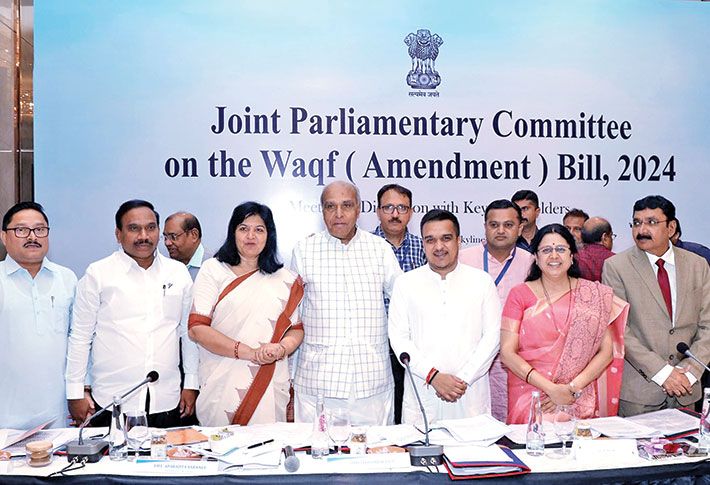
The deadlock continued until 2024, when a Joint Parliamentary Committee (JPC) was convened in New Delhi to assess the national status of WAQF properties. During this high-level review, the situation in several states, especially Madhya Pradesh, came under sharp scrutiny. The findings were startling and acted as a national wake-up call:
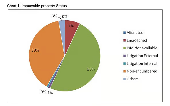
A large number of WAQF properties in Madhya Pradesh were found to be untraceable, undocumented, or embroiled in legal disputes, with many properties under encroachment by private individuals and, in several cases, even government institutions unknowingly occupying WAQF land. Significant discrepancies existed between the WAQF Board’s internal records, Revenue Department data, and the on-ground reality, rendering lawful governance and effective management nearly impossible. The absence of a centralized digital system to monitor, verify, and validate the existence, condition, and usage of these properties further aggravated the problem.
The Need for a Paradigm Shift

The JPC proceedings made it absolutely clear: unless a transparent, digitally robust, and community-participatory governance system was introduced, WAQF properties would continue to be lost—physically, legally, and morally.
Thus, the Madhya Pradesh government, facing both external pressure from the parliamentary committee and internal realization of the dire condition, decided to act decisively.
The outcome was the conceptualization and launch of WAMSI-MP, an initiative designed not only to digitize and verify the WAQF properties but also to rebuild trust, restore legality, and empower both officials and stakeholders.
In addition, the system aimed to eliminate long-standing clerical loopholes and bring uniformity across all district-level operations. It introduced data-driven monitoring tools to ensure timely action and accountability. Most importantly, it opened a direct channel for community participation, ensuring that beneficiaries were no longer distant observers but active contributors.

System Design

Bulk Digitization

Manpower Management

Ground Verification (GIS)

Pilot Launch - Rewa

Scale Across Districts

Technology & Trust
Designing the System: From Concept to Execution
The team started from scratch—designing a digital framework that could accommodate historical, scattered, and often illegible records.
- A web-enabled platform was envisioned with multilingual capabilities
- Modules included GIS mapping, GPS rover-based validation, legal document verification, and cross-linking with RoR (Records of Rights)
- The backend was fortified with dashboards for real-time monitoring, approval workflows, and compliance tracking
The team built the system from the ground up, ensuring it could handle scattered, historical, and often unreadable records.
What made this design unique was its aim to blend technology with religious sensitivity—ensuring transparency without compromising the sanctity of WAQF estates.Importantly, the system was designed to integrate with e-Parta, enabling authenticated digital certificate generation and seamless verification of property-related records. This ensured that WAQF asset data could be validated and shared with government systems in a secure, paperless manner.
The backend incorporated real-time dashboards, approval workflows, and compliance tracking. A key addition was e-Parta integration, enabling secure digital certificate generation and authenticated record verification.

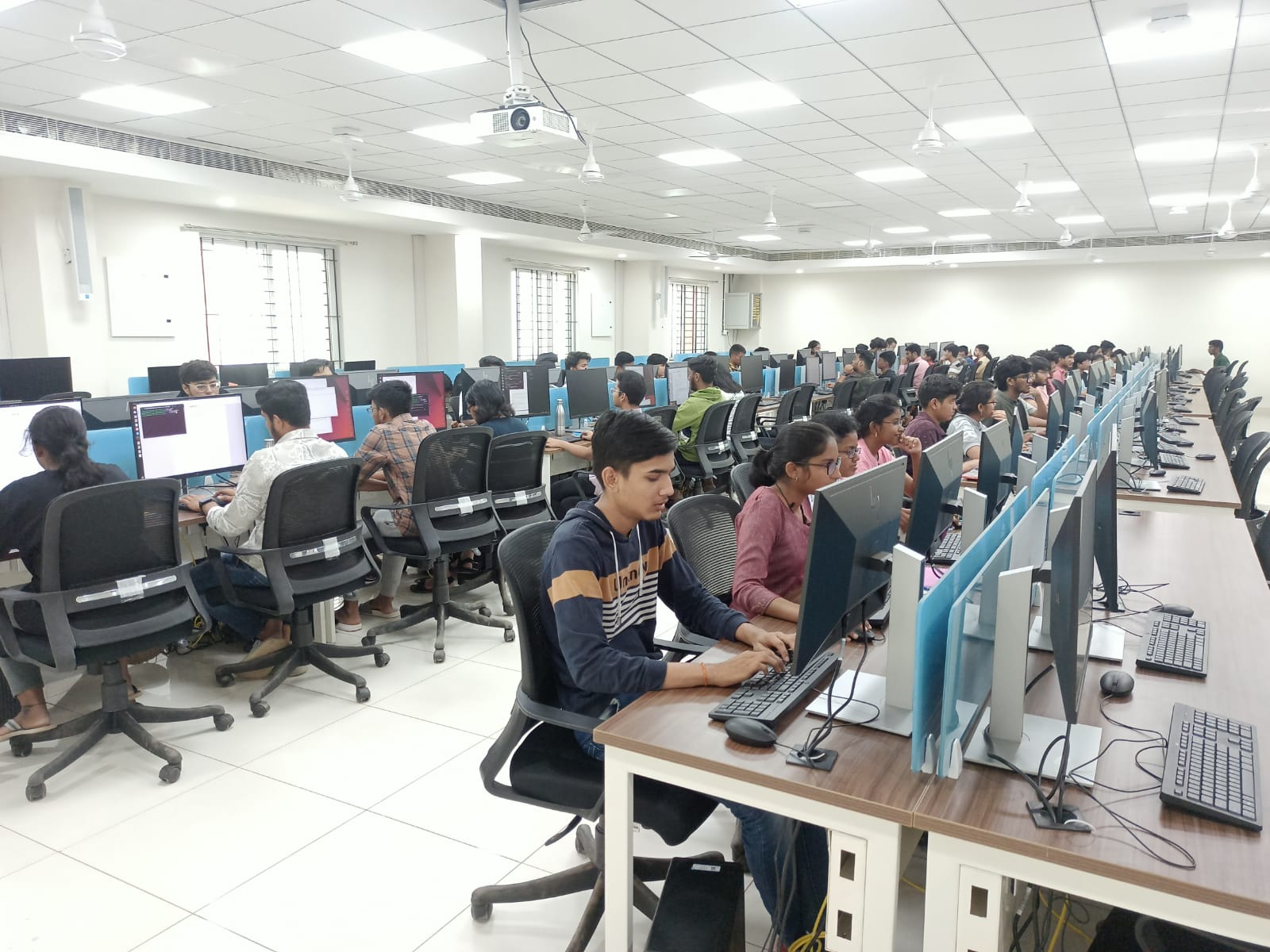
The Herculean Challenge: Entering 15,000+ Properties in Just 3 Days at a Single Command Centre
Perhaps the most audacious milestone in the WAMSI-MP journey was the bulk digitization of over 15,000 WAQF properties—achieved in just 3 to 4 days from a single centralized control location.
- A dedicated Data Entry War Room was established in Bhopal with over 500 trained operators working
- Operators were brought in from across the state, accommodated in temporary facilities, and briefed intensively
- The source material: handwritten AUKAF registers, often in Urdu or archaic formats, requiring translation, deciphering, and double verification
Each operator worked tirelessly to interpret and convert decades-old manual entries into structured digital records, fill in comprehensive forms including details of land type, usage, registration, and location, and flag inconsistencies for supervisory review.
This was not just data entry—it was a rare display of coordination, conviction, and commitment by all stakeholders.

Managing Manpower and Overcoming Resistance
The mobilization of hundreds of personnel within a short window required meticulous planning—from logistics and security to data allocation and real-time monitoring.
- Local-level resistance continued with misinformation that the data might be used to seize land
- Special helplines, nodal grievance officers, and on-ground communication teams were deployed to defuse tension and build trust
- Despite formidable challenges, the team completed the task on time, with near-zero data loss and high accuracy
This base digital repository would later power advanced modules like field verification, satellite integration, and GIS-based land mapping.
To strengthen reliability, the system was continuously tested under simulated high-load conditions. Training modules were rolled out to ensure uniform understanding across districts. The streamlined dataset ultimately became a single source of truth for future policy decisions and automation.
In parallel, the administration implemented a phased quality audit to validate every batch of incoming records. Independent review teams were tasked with flagging anomalies, ensuring that no manipulated or inconsistent entries slipped through. This rigorous validation framework not only enhanced credibility but also set a benchmark for future digital governance drives.
Ground-Level Verification and GIS-Based Transparency: The District Rewa Pilot and Beyond
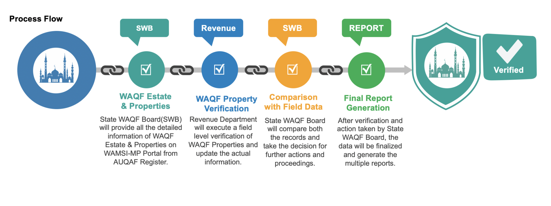
Once digitized records were compiled, the next critical step was verifying entries on the ground—physically locating properties, confirming boundaries and usage, and comparing field findings with digitized records.
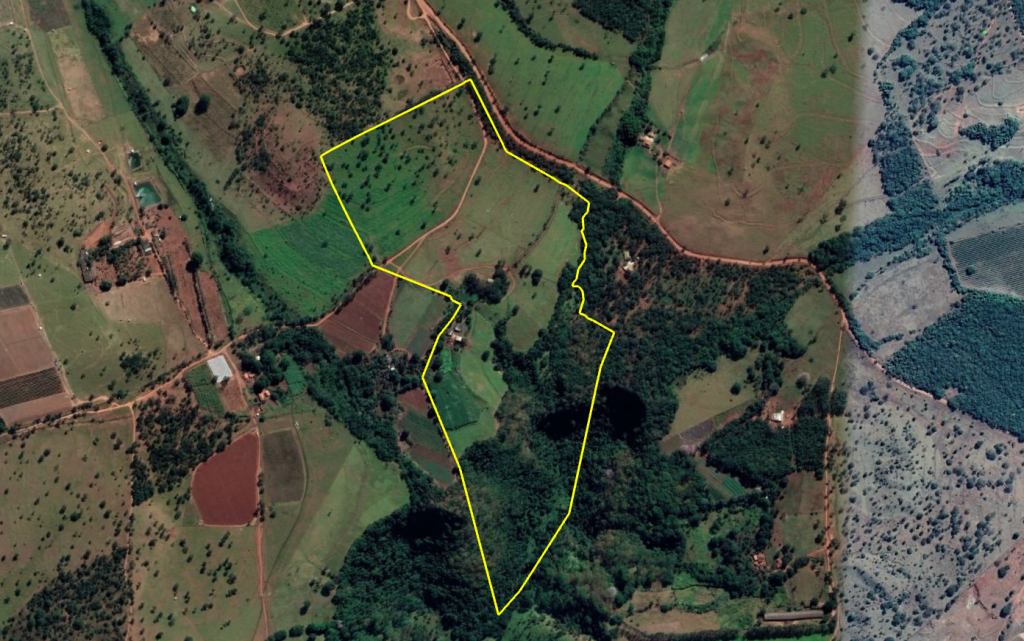
- A robust web-based GIS solution was deployed where officials uploaded KML files with GPS coordinates and real-time photographs
- Every submission was geotagged and timestamped, enabling real-time monitoring and dashboard-based tracking
- This phase was the most sensitive and effort-intensive aspect of the entire mission
In essence, this verification phase turned WAMSI-MP from a database into a movement of digital accountability, with GIS as the backbone of its trust-building efforts.
The system also empowered district-level officials with structured workflows. Alerts were auto-generated whenever the field data did not match historical RoR entries or earlier survey records, enabling supervisors to intervene instantly. This not only reduced verification time but also curbed the possibility of manipulation, since every action—from field upload to approval—left a digital footprint.
Pilot Launch in District Rewa: A Model for Scalable Field Implementation
The district of Rewa was strategically selected as the pilot zone for on-ground verification and GIS-based mapping.
- A dedicated field team of GIS engineers, WAQF officials, and surveyors was mobilized
- Teams were trained to capture GPS data and convert it into KML format
- The teams matched AUKAF digital data with on-ground plots
The Rewa pilot unearthed several critical realities:
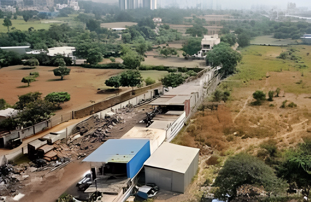
- Many WAQF properties were found in disputed or partially encroached zones
- Several properties were difficult to locate physically due to outdated or inaccurate register entries
- In some cases, locals resisted the verification process, suspecting government acquisition
Higher-level administrative intervention became essential to facilitate cooperation and ensure team safety.
Scaling the Verification Process Across Districts
Building on the success from Rewa, the model was rolled out in a phased manner across other districts.
The workflow remained consistent:
- Physical visit to each site
- GPS reading capture and generation of KML file
- Upload of geo-tagged photos, land use status, encroachment remarks, and digital verification notes
Each team faced unique challenges:
- Some locations were unapproachable due to terrain or community pushback
- Some Mutawallis refused cooperation out of fear, suspicion, or local political pressure
- There were cases where no trace of the registered property could be found
Yet, despite these hurdles, a statewide verification campaign gained momentum due to robust administrative backing, clear SOP-based execution, and public assurance mechanisms.

Technology as a Trust Builder
A crucial breakthrough was the use of web-based GIS tools that displayed:
- Satellite-backed WAQF property boundaries
- Status of physical verification (Pending/Verified/Disputed)
- Layers showing encroachments, ownership history, and RoR integration
This visibility turned the tide of public sentiment. Once community stakeholders, religious leaders, and local officials saw their property legally documented and digitally visible, they began offering support voluntarily.
WAMSI-MP thus became more than a portal—it became a platform of transparency, inclusion, and digital empowerment.

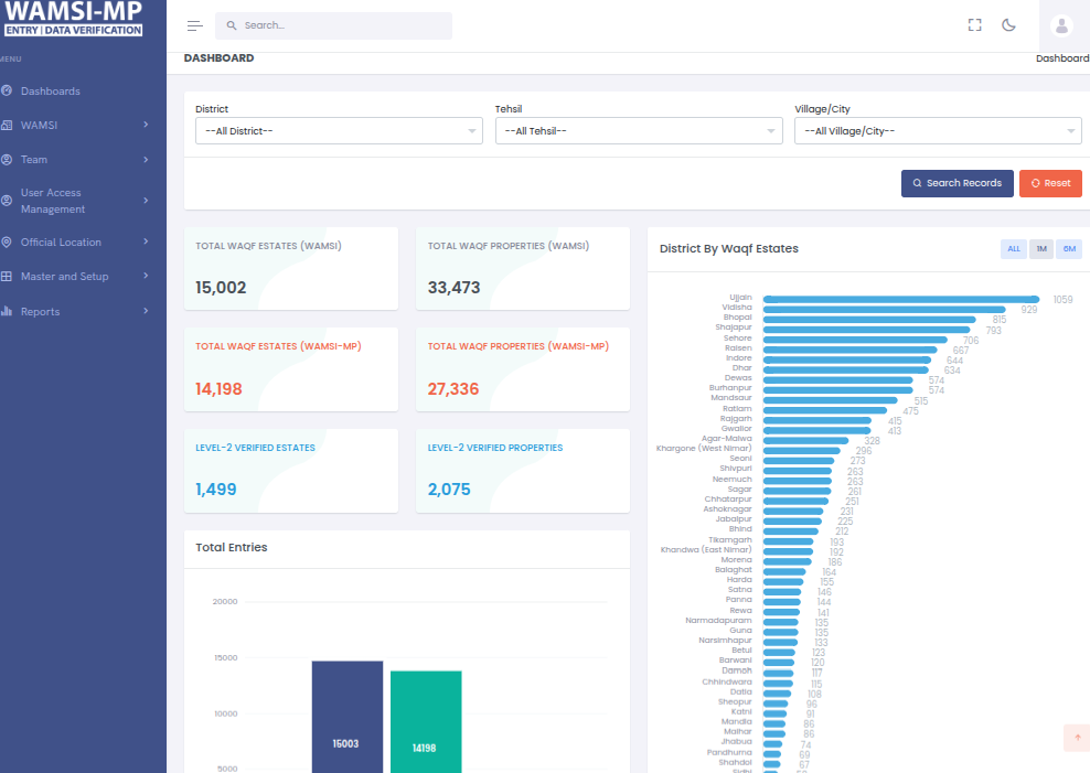
Tangible Outcomes and Systemic Impact
The implementation of WAMSI–MP has fundamentally transformed WAQF property management in Madhya Pradesh from a fragmented, paper-based process into a digitally empowered, transparent, and verifiable system.
Through large-scale digitization and GIS-backed validation, over 15,000+ WAQF properties were systematically documented, mapped, and cross-linked with revenue and tribunal records. This comprehensive database now provides a single source of truth for all WAQF assets across the state.
The introduction of real-time dashboards, monitoring tools, and data-driven workflows has enabled officials to make informed decisions instantly. Property ownership, boundary details, encroachment status, and legal disputes can now be tracked and updated centrally without dependency on physical files.
This has improved administrative efficiency, ensured accountability at every level, and provided complete visibility into the lifecycle of each asset—from registration to field validation.
In essence, WAMSI–MP has created a sustainable digital governance infrastructure that strengthens transparency, improves coordination between departments, and restores public trust in WAQF management.

Legal Empowerment and Institutional Strengthening
One of the most transformative outcomes of WAMSI–MP has been the legal empowerment of the Madhya Pradesh WAQF Board. Every digitized property record within the system is supported by a chain of documentary evidence—including scanned ownership documents, mutation records, GIS coordinates, and geo-tagged photographs. This has made each property legally defensible and verifiable in any judicial or administrative setting.
The system's integration with tribunal and encroachment tracking modules has allowed the Board to identify, record, and act upon disputed or encroached lands with unprecedented precision. Previously, the absence of authenticated evidence often led to weak legal positions and delays in restitution.
Today, the Board can produce digitally verifiable evidence to initiate or defend cases, issue recovery notices, and coordinate directly with legal authorities.
Furthermore, the structured digital documentation has enhanced internal accountability—enabling audit trails, verification logs, and role-based actions to be tracked for every user. This has effectively shifted the Board from reactive administration to proactive legal governance, ensuring that WAQF properties remain protected, traceable, and lawfully managed.
The Future Path and Road Ahead
WAMSI–MP is not a one-time digital intervention but a living governance ecosystem that continues to evolve. Building on its success, the next phase focuses on automation, integration, and community transparency.
Lease and Encroachment Management Modules for automated lease renewals, rent tracking, and encroachment redressal workflows. Advanced Legal Analytics to monitor litigation progress, case timelines, and restitution performance through data dashboards. Public Transparency Portal allowing citizens and Mutawallis to view verified property details, submit feedback, and track dispute resolution.
Cross-Departmental Integrations with Revenue, Urban Local Bodies, and National WAMSI systems for complete data interoperability. Additionally, the Madhya Pradesh model is being proposed for adoption by other states, given its replicable architecture and governance outcomes. It demonstrates how sensitive, legally complex religious assets can be managed through data integrity, transparency, and institutional collaboration.