Fragmented and Siloed Land Records Across Multiple Authorities

Industrial land data was maintained independently by MPIDC, the Revenue Department, Town & Country Planning, and local bodies, each following its own formats, update cycles, and validation mechanisms. These silos resulted in multiple versions of the same land information, often contradicting each other in terms of plot boundaries, area measurements, land use classification, and allotment status. In the absence of a centralized repository, verification of land details required manual reconciliation across departments, leading to delays, administrative disputes, and uncertainty for both officials and investors. This fragmentation weakened institutional coordination and prevented the creation of a unified, reliable land governance framework.
Absence of Accurate Spatial Demarcation and Ground-Truth Validation
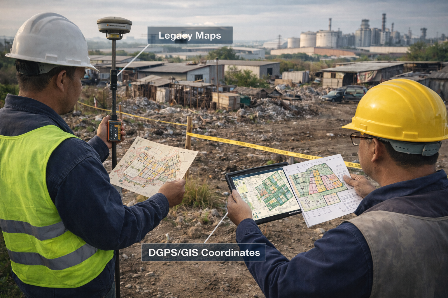
Most industrial areas and plots were defined through textual descriptions, hand-drawn layouts, or legacy maps that lacked spatial precision. Without DGPS-based boundary demarcation and GIS-linked coordinates, land records were vulnerable to overlaps, boundary ambiguities, and disputes with allottees or adjoining landowners. Ground realities such as encroachments, partial occupations, or infrastructure changes were not systematically reflected in official records. This disconnect between records and reality undermined the legal reliability of land data and made dispute resolution time-consuming and complex.
Outdated Master Plans and Misalignment with Actual Development
Over time, industrial estates underwent multiple changes—new roads were built, utilities were expanded, plots were merged or subdivided, and land use patterns evolved. However, master plans were not updated at the same pace. As a result, officially approved layouts often failed to reflect existing infrastructure and current land utilization. This misalignment created challenges in compliance monitoring, infrastructure planning, and approval of new projects, as decisions were being made on the basis of outdated information rather than current ground conditions.
Limited Transparency and Real-Time Visibility of Land Availability

There was no centralized, real-time system to track the status of industrial plots across the state. Information on whether a plot was vacant, reserved, allotted, under litigation, or encroached was scattered and often outdated. Investors had to rely on physical visits, manual confirmations, and informal communication to assess land availability. For administrators, the lack of live data limited their ability to monitor land utilization, identify high-demand zones, or plan timely expansion of industrial infrastructure. This opacity reduced investor confidence and slowed down decision-making.
Weak Mechanisms for Monitoring Encroachments and Compliance

Encroachments and unauthorized land use accumulated gradually due to the absence of systematic monitoring tools. Manual inspections were infrequent and reactive, making it difficult to detect deviations at an early stage. Without spatial overlays and digital comparison of records versus ground reality, authorities lacked evidence-based mechanisms to initiate regularization, enforcement, or corrective planning. Over time, this weakened regulatory oversight and reduced the effective availability of industrial land.
Manual, Time-Consuming Processes Affecting Ease of Doing Business

Land verification, allotment, and monitoring processes depended heavily on physical files, site inspections, and inter-departmental correspondence. These workflows were slow, unpredictable, and highly dependent on individual coordination, leading to extended approval timelines. For investors, this translated into uncertainty, higher transaction costs, and delayed project execution. In a competitive investment environment, such procedural delays reduced the state’s ability to attract and retain industrial investments.
Inability to Support Data-Driven Planning and Strategic Decision-Making

The absence of accurate, consolidated land data constrained the government’s capacity to plan new industrial areas, prioritize infrastructure investments, and align land allocation with sectoral policies. Decisions related to expansion, pricing, zoning, and promotion of industrial clusters were often based on partial or outdated information. A GIS-based digital platform was therefore essential to enable evidence-driven policy formulation, long-term planning, and sustainable industrial growth.

Policy Vision

System Planning

GIS Execution

Platform Integration

Institutional Adoption
Ideation: Establishing the Policy and Governance Vision
The ideation phase laid the strategic and policy foundation for the GIS-Based Industrial Land Bank and was driven by the recognition that industrial land governance required systemic reform rather than incremental improvement. MPIDC, in consultation with planning authorities and technical experts, undertook a comprehensive assessment of existing land management practices, legacy records, and institutional workflows governing industrial land across the state.
This assessment revealed that the core challenge was not the absence of land, but the absence of reliable, spatially accurate, and administratively unified land information. Land records were dispersed across departments, maintained in different formats, and rarely updated to reflect ground reality. Boundary descriptions were largely textual, master plans were static, and there was no mechanism to link land availability with infrastructure, compliance, or investment planning. These gaps resulted in prolonged verification cycles, land-related disputes, and reduced investor confidence.
Recognizing these structural limitations, the ideation phase reframed industrial land management as a governance and policy issue, not merely an operational one. The vision was articulated to establish a single, authoritative GIS-based land governance platform that could integrate spatial data with administrative records, eliminate ambiguity, and support real-time decision-making. The proposed system was designed to align with broader policy objectives, including Ease of Doing Business reforms, industrial promotion, transparency, and long-term infrastructure planning. This clear articulation of purpose ensured strong institutional ownership and policy alignment from the outset. .
Planning: Designing a Scalable, Legally Reliable, and Governance-Ready Framework
Following the establishment of the policy vision, the planning phase focused on translating strategic objectives into a detailed, implementable, and scalable system design. This phase involved close coordination between MPIDC officials, planning authorities, and GIS experts to define technical standards, administrative workflows, and validation mechanisms that would govern the implementation.
Detailed planning workshops were conducted to identify all required GIS layers, including industrial area boundaries, plot parcels, internal roads, utilities, green zones, land use zoning, and encroachments. Data standards such as coordinate reference systems, attribute schemas, and naming conventions were finalized to ensure uniformity across all industrial areas. Particular emphasis was placed on ensuring that the GIS outputs would meet administrative and legal requirements, enabling their use for approvals, planning, and monitoring without parallel manual validation.
A phased rollout and execution strategy was developed to manage scale and operational complexity. Industrial areas were prioritized based on investment potential, development status, and policy importance. Survey methodologies using DGPS and drones were standardized, and protocols were defined for ground-truth validation and joint departmental verification. Risk mitigation measures were also incorporated into the plan to address challenges such as data inconsistency, field access constraints, and inter-departmental coordination. This detailed planning ensured that the implementation would be methodical, scalable, and capable of delivering a sustainable governance reform rather than a one-time digitization exercise.


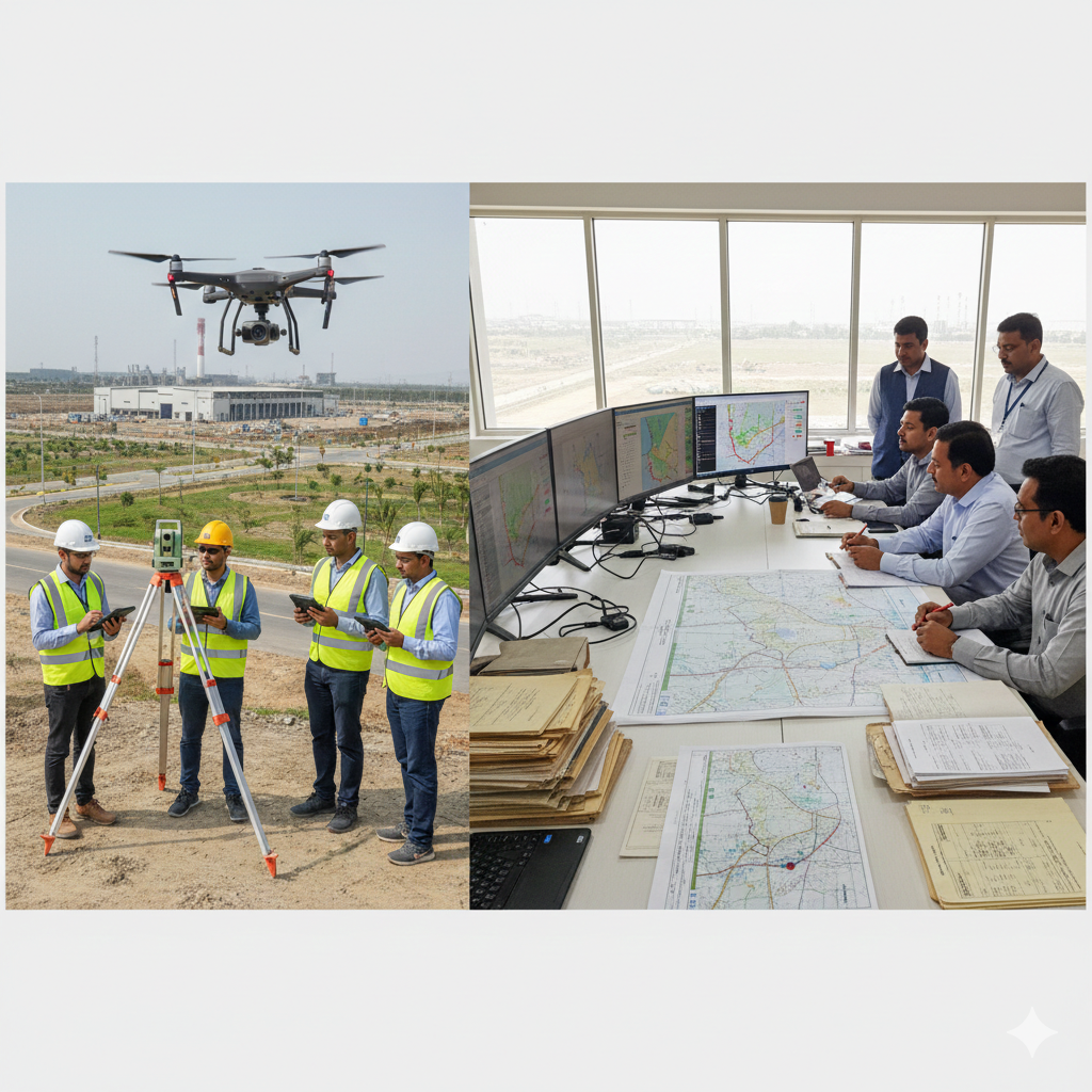
Execution: Statewide GIS Mapping and Data Creation
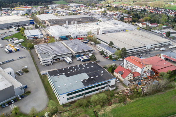
The execution phase marked the most resource-intensive and operationally complex stage of the GIS-Based Industrial Land Bank initiative. It involved translating the conceptual GIS framework into accurate, ground-validated digital land records across 119 industrial areas, encompassing existing, developing, and greenfield zones. A standardized execution methodology was adopted to ensure uniformity, accuracy, and administrative acceptance across all regions.
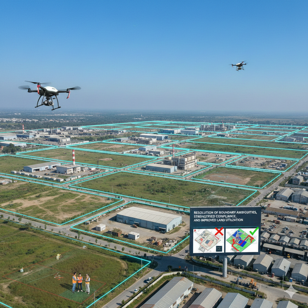
High-precision DGPS surveys and drone-based aerial mapping were conducted to capture exact spatial coordinates of industrial area boundaries, individual plots, internal roads, utilities, green belts, and common facilities. Field teams followed predefined survey protocols and coordinate systems to maintain consistency in spatial data collection. Parallelly, extensive field verification exercises were undertaken to capture on-ground realities such as encroachments, partial occupations, infrastructure deviations, and non-conforming land use.
Legacy paper records, including allotment registers, layout plans, and historical maps, were digitized and geo-referenced alongside the newly created spatial datasets. Detailed reconciliation was performed to identify discrepancies between legacy records and ground conditions. Joint verification sessions with MPIDC and departmental officials ensured that all corrections, boundary adjustments, and status updates were formally validated. This collaborative execution approach ensured that the resulting GIS datasets were not only technically accurate but also institutionally accepted for governance and planning purposes.
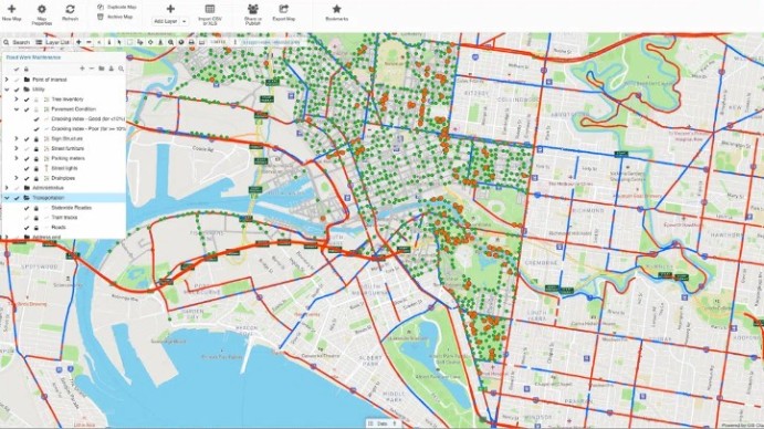
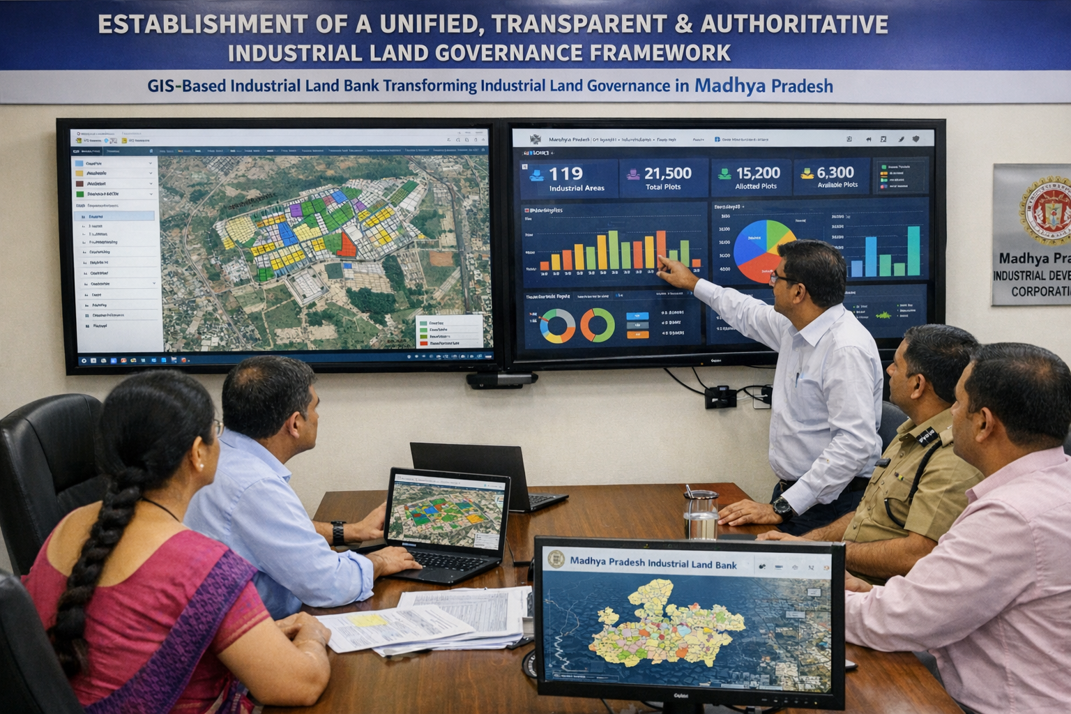
Integration: Creation of the Centralized GIS Land Bank
Following data creation and validation, the focus shifted to integrating all spatial and non-spatial datasets into a centralized GIS-based Industrial Land Bank platform. Each industrial plot was linked with its corresponding administrative attributes, including land use classification, allotment status, infrastructure availability, and compliance indicators. This integration transformed disparate datasets into a unified, intelligent land governance system.
The platform was configured to support real-time updates, enabling administrators to view current land availability, utilization patterns, and spatial context through interactive GIS dashboards. Analytical layers were introduced to support land utilization analysis, infrastructure gap assessment, and identification of high-demand industrial clusters. By consolidating data into a single system, the platform eliminated duplication, reduced dependency on manual verification, and established a single source of truth for industrial land information across the state.
In addition to administrative use, the integrated GIS land bank significantly improved transparency and investor facilitation by enabling accurate, location-specific land information to be accessed quickly. This integration phase effectively converted static land records into a dynamic, decision-support system aligned with policy, planning, and Ease of Doing Business objectives.

Stabilization and Institutional Adoption
The stabilization phase focused on embedding the GIS-Based Industrial Land Bank into routine administrative and governance processes. Standard operating procedures were defined for data updates, validation, and approval workflows to ensure that the system remained accurate and current over time. Clear roles and responsibilities were established for officials responsible for maintaining land records, updating plot status, and validating changes.
Capacity-building initiatives and orientation sessions were conducted to familiarize officials with GIS dashboards, analytical tools, and reporting features. The system was positioned as the primary reference platform for industrial land information, significantly reducing reliance on parallel manual records and informal data sources. Audit trails and access controls were implemented to strengthen accountability and data integrity.
Over time, the platform evolved into a stable and trusted governance tool supporting land planning, monitoring, and decision-making. Its institutional adoption ensured long-term sustainability of the reform, enabling Madhya Pradesh to manage industrial land proactively, transparently, and in alignment with evolving industrial policy priorities.

Establishment of a Unified, Transparent, and Authoritative Industrial Land Governance Framework
The GIS-Based Industrial Land Bank has fundamentally transformed industrial land governance in Madhya Pradesh by establishing a single, centralized, and authoritative source of truth for industrial land across 119 industrial areas. Prior to the reform, land information was fragmented across multiple departments, resulting in inconsistencies, duplication, and ambiguity. By integrating high-precision spatial data with verified administrative records, the initiative has eliminated these discrepancies and ensured that all stakeholders—planners, administrators, and investors—operate on a common, reliable dataset.This unified governance framework has significantly enhanced transparency and institutional credibility. Decision-making related to land planning, allotment, monitoring, and infrastructure development is now based on accurate, real-time, and spatially validated information rather than manual interpretation of legacy records. The availability of a trusted digital land repository has strengthened inter-departmental coordination, reduced discretionary decision-making, and institutionalized rule-based land governance across the state.
Resolution of Boundary Ambiguities, Strengthened Compliance, and Improved Land Utilization
High-precision DGPS surveys, drone-based GIS mapping, and systematic ground-truth validation have resolved long-standing ambiguities related to industrial area and plot boundaries. Earlier, boundaries were defined through textual descriptions and outdated layouts, leading to overlaps, disputes, and frequent corrections. The reform has aligned official records with actual ground conditions, providing legally and administratively defensible spatial demarcation of industrial land. This spatial clarity has significantly strengthened compliance monitoring and land utilization efficiency. Encroachments, unauthorized occupations, and land-use deviations can now be identified early through GIS overlays and spatial analysis. Authorities are better equipped to initiate timely regularization or enforcement actions, reducing prolonged disputes and preventing loss of industrial land. As a result, industrial land is now managed more efficiently, with higher regulatory discipline and optimized utilization aligned with approved land-use plans.
Improved Administrative Efficiency and Tangible Ease of Doing Business Outcomes
The digitization and integration of land records into a centralized GIS platform have substantially improved administrative efficiency within industrial land management processes. Manual file handling, repetitive verification, and inter-departmental correspondence have been largely replaced by digital workflows and GIS dashboards. Officials can now access plot-level information, infrastructure availability, and compliance status instantly, enabling faster reviews, approvals, and coordinated decision-making across departments. For investors, this administrative efficiency has translated into greater predictability and reduced project timelines. Faster identification of suitable land parcels, clearer understanding of land status, and reduced verification delays have shortened project gestation periods. By addressing one of the most critical bottlenecks in industrial investment—land availability and clarity—the initiative has made a direct and measurable contribution to improving Ease of Doing Business outcomes and strengthening Madhya Pradesh’s competitiveness as an investment destination.
Data-Driven Planning, Policy Enablement, and Long-Term Institutional Capacity Building
The availability of spatially integrated, analytics-ready land data has enabled a decisive shift from reactive administration to data-driven planning and policy formulation. Authorities can now analyze land utilization patterns, assess infrastructure gaps, identify high-demand industrial zones, and plan future industrial expansion with greater precision. This evidence-based approach supports better alignment between land allocation decisions, sectoral priorities, and regional development strategies. Beyond immediate operational benefits, the institutional adoption of the GIS-Based Industrial Land Bank has strengthened long-term governance capacity within the industrial development ecosystem. Standardized processes for data updates, validation, and audit trails have reduced dependence on parallel manual records and ensured sustainability of the reform. The scalable architecture of the platform provides a strong foundation for future integrations, advanced analytics, and policy-driven enhancements, positioning Madhya Pradesh as a digitally mature and forward-looking state in industrial land governance.